
map.apps 4.1 - What's New
A new version of map.apps 4 is available for download. This includes bundle packages 4.1.0 and 3.8.0. This article describes the improvements in both versions.
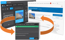
Demonstrating security.manager – ArcGIS Edition

In a previous blogpost about security.manager, we focussed on using access control to work smarter with data and WebGIS Resources. Since then, we’ve had numerous requests to show how this actually works in the real world, and specifically, how we extend and enhance the ArcGIS Platform with fine-grained access control.
Dive in a new dimension

In municipal, state or federal administrations, in European data portals, but also in the most varied sectors of the private economy, map.apps enables efficient app-based use and integration of geo-information in public or company-wide infrastructures.
New Release: Even more flexibility with service.monitor 4.2.0
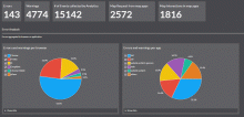
service.monitor 4.2.0 brings noticeable improvements in the configuration of the Analytics dashboards. Dashboards can either use the globally predefined widgets of the product or define queries locally in the individual app. A blog article that will be published in the next days will explain the advantages of the new configuration step by step.
The heatmaps for the representation of specific areas of interest are also more flexibly configurable and can be used in further spatial reference systems.
Stay in control (and still serve everybody’s needs)

Access control is an important part of any security consideration, but did you know that it can do more for you than just blocking access to content that certain groups should not see?
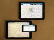
Build apps for all environments
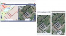
Multiplatform technology with map.apps for the official real estate market information system in the State of North Rhine-Westphalia
At the beginning of 2016, the new BORISplus.NRW 3.0 was released online, initially as a web app optimized for the desktop. In a second step, the app was made responsive, thus optimizing its use for tablets and mobile devices. Since the end of August 2016, the BORISplus Services of the state of NRW can now be used as real apps for iOS, Android and Microsoft. The BORISplus.NRW app can be obtained directly from the respective app stores.
New Bundle Download: Take users in hand with Intro JS
Focused apps are built with map.apps, tailored to the needs of users and easy to use. A brief explanation of individual functions, even with very focussed apps, can contribute to making a much more positive user experience, especially for new users.
These explanations should be directly related to the application and the respective functions, and appear at the right time in the right place. To achieve this and avoid that extra help on a separate page must be called, there is now a new free bundle download: IntroJS
Native Apps for iOS, Android and Windows 10 with map.apps
From version 3.5, advanced Maven processes are now available for the multi-device capabilities of map apps. These can be scripted using Apache Cordova from existing Web applications create native apps for iOS, Android and Windows 10 (universal).
service.monitor 4.1 released
The rollout of service.monitor 4.1, to all existing customers, will start this week.
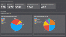
Analytics - new query dashboards
For analytics, the product offer new dashboard definitions, focussing on concrete question of analytics users.
Now available for download: New spatial selection options with the Advanced Selection bundle
map.apps already offers standard functions to select features via the selection tool by dragging a rectangle (or circle, etc...) or by "drawing" multiple graphic shapes on the map, and displaying the seleciton results in the Result Center.
A new bundle, "Advanced Selection", now enables advanced spatial selection options, which may be quite complex in nature. Different selection methods are provided in a central selection widget. These are intuitive and optimized to be able to perform more complex selection methods with a few clicks, which till now may have required several operations.