
A new version of map.apps 4 is available for download. This includes bundle packages 4.1.0 and 3.8.0. This article describes the improvements in both versions.
Bundle Package 4.1.0
Register apps in Portal for ArcGIS and ArcGIS Online
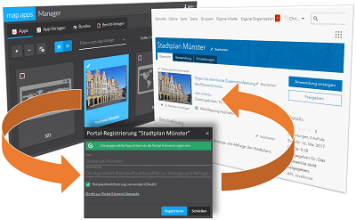 Administrators and editors can now register their map.apps apps directly from the map.apps Manager as an application on Portal for ArcGIS or ArcGIS Online. To do this, the title, the description and the app thumbnail can be directly taken over. In addition, it is possible to enable portal authentication, so users need a portal identity when accessing the app. The use of protected portal content in the app is thus via SSO. In the app overview you can see directly which app is stored in the portal and for which authentication is activated.
Create standalone apps
In addition, it is possible to create a standalone app via the map.apps Manager. Standalone app means that map.apps finds all the resources needed for the app (e.g., JavaScript files, images, styles) and stores it with the app configuration in a ZIP archive. This can be downloaded via the map.apps manager and in a second step, for example, via Apache Cordova to a native (hybrid) application. The mechanism includes, in addition to the map.apps bundles and those of the product extensions, self-developed bundles.
Streamlayer Support
With this version of map.apps, it is possible to integrate real-time data provided by an ArcGIS GeoEvent Server into map.apps. These data are not requested by the client, but are sent from the server to the map, unlike the other map services. In addition to 2D content, the data can also be displayed in a 3D map via the streamlayer.
Other Improvements
In addition to further optimizations and bug fixes, the ArcGIS API for JavaScript has been updated to version 4.2. This makes it possible to use vector tiles not only in 2D maps, but also in 3D maps.
Bundle Package 3.8.0
Printing
Via the print dialog, it is now possible to rotate the map image in the print output. The user can freely enter the angle or select a predefined direction.
Streamlayer Support
In addition, the streamlayer for the display of real-time data has also been integrated into the bundle package via the ArcGIS GeoEvent Server. The corresponding layers can be selected via the live configuration of an app and assigned to the map.
Other Improvements
As well as bug fixes, this bundle package also includes an update to the ArcGIS API for JavaScript 3.19. In addition, usability optimizations have been made based on user studies, for example, the Map Flow funciton. Here, the display of the tiled state and the icons used were made clearer.