
With map.apps 4.6, a new version of map.apps is available for download, which brings new features for line 4 and updates to the basic technology of map.apps. The release also includes a new version of line 3. This article gives an overview of all the major new features and presents them in detail.
Measurement in 2D maps
After the measurement of distances and surfaces in 3D scenes was made possible in map.apps 4.5, the measurement of surfaces and distances in 2D maps is now also available.
The measurement function has been completely reworked and improved compared to map.apps Line 3. The measurement result is now additionally displayed in the map and can be printed. Furthermore, the unit changes automatically between e.g. meters and kilometers depending on the size of a measurement. When measuring areas, the circumference of an area is now also indicated.
If a point is to be corrected during a measurement, the Z and R keys can be used to undo or repeat the setting of points.
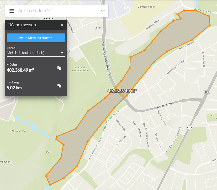
The functions for measuring areas and distances can be offered independently (individually) in an app.
Performance Improvement through WebGL Rendering
With this release the rendering mechanism WebGL becomes the standard for all layers in a map (for apps of line 4). Among other benefits, this brings a significant improvement in performance, especially when displaying a large number of objects on a map. In addition, objects for which a popup is opened are highlighted in the map.
The example below shows the representation of tens of thousands of points of a feature layer drawn in the browser.
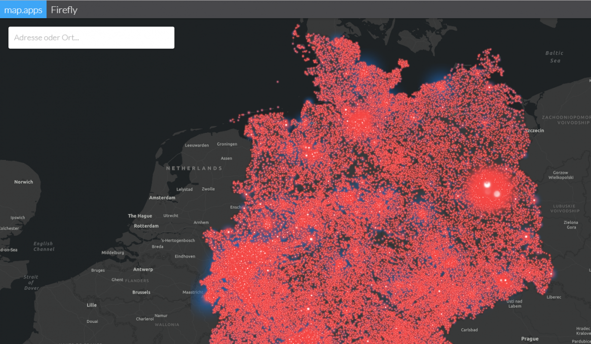
In previous releases, WebGL was already available as an option, but only certain services were supported in certain ArcGIS versions. This restriction no longer applies, so all layers can now be drawn in a single WebGL context. Further information on WebGL rendering is described here by Esri.
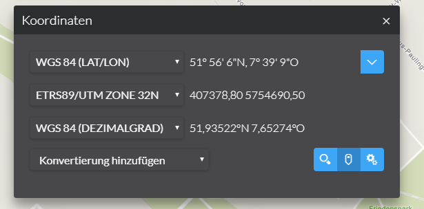
New formats for coordinate transformation and search
The function for transforming and searching coordinates introduced in map.apps 4.5 has been further enhanced in this version. The list of available formats has been extended to include the following particularly common formats in Germany:
- DHDN Gauss-Krueger (Zone 2 - 5)
- ETRS89/UTM zone 32N
- ETRS89/UTM zone 33N
- WGS 84 Pseudo-Mercator
- WGS 84 (lat/lon)
- WGS 84 (decimal degree)
It is also now possible to configure the formats offered to the user.
Improved filter in result center
After selecting objects in the map, an entry is displayed in the Result Center for each map layer. A filter can be used to hide running, erroneous and unsuccessful entries from this list. This filter can now be activated automatically at startup to allow a more intuitive selection behavior.
In addition, the filter is only displayed if it is useful at all (i.e. not if all layers return results). The filter can also be completely hidden by configuration.
Further improvements
Increase of product UX
In this release improvements have been added again to enhance the user experience, e.g:
- In the search, if you are able to switch between several search topics, a dropdown arrow is displayed instead of a cogwheel, describing this possibility more intuitively.
- In the map.apps Manager, you can now filter for bundles of line 3 or line 4 in the "Developer Network Bundles" tab.
- In map.apps Manager, the manual configuration is now opened directly at full screen height.
Support for Apache Tomcat 9
This version introduces official support for Tomcat 9.
Update of ArcGIS API for JavaScript
The version of the ArcGIS API for JavaScript used in map.apps has been updated to version 4.10 (from version 4.8). Both versions 4.9 and 4.10 bring important improvements and new possibilities. These include a multitude of new methods, classes and bugfixes as well as improvements in the display of web scenes, new widgets, 3D mouse and gamepad navigation and much more.
A complete overview of the changes can be found in the release notes of the ArcGIS API for JavaScript.
Update of the UI library Vuetify
map.apps 4.6 also includes an updated version of the Vue-based UI library Vuetify (version 1.3.8). This update allows map.apps developers to use completely new UI components (e.g. a tree component) and to benefit from library optimizations since the previous used version 1.0.
A complete overview of all changes can be found in the Vuetify Release Notes from 1.0.18 to 1.3.8.
Final notes
In addition to the above, this release contains further improvements and bug fixes for both line 3 and line 4. As always, a complete list of all changes can be found in the Release Notes. If you are updating an existing map.apps installation to this version, please refer to the detailed notes in the Release Notes - especially if you have developed your own bundles based on Vuetify. Please also check that you always use the latest versions of the Developer Network bundles.