
A new version of map.apps 4 is available for download. The new version offers comprehensive new possibilities for both map.apps administrators as well as developers. This article describes the innovations that map.apps 4.2 brings with it.
One Software – Two Lines
To better understand the new features of map.apps 4.2, it is important to understand that since 2016, ESRI has two APIs which allow you to interact with the ArcGIS platform: the classic ArcGIS API for JavaScript version 3 and the young, still under development version 4.
map.apps has been supporting both APIs in parallel since version 4.0. This allows map.apps users to profit from the great functionality of version 3 as well as very early from the brand new features of version 4.
The ArcGIS API for JavaScript version 3 is supported by the tried and tested map.apps bundles 3.x. This line of technology is called Line 3.
Similarly, we have been building the so-called line 4, which contains the map.apps ArcGIS API for JavaScript version 4 and map.apps Bundles 4.x. Line 4 is a further development from con terra, with simplified programming, new functions and expanded concepts.
Users of map.apps 4.2 decide which line is to be used for each app. Proven existing apps based on on line 3 can continue to be used, maintained and expanded. If new functions are to be used, such as 3D, then corresponding apps can be created on the line 4 and be complemented seamlessly. map.apps organizes the central and easy operation of all apps in a single installation.
In the following, we present the current innovations differentiated according to the two lines.
Line 4
Bundle-Packet 4.2.0 (based on ArcGIS API for JavaScript 4)
Control of Maps in 2D and 3D
The Map Flow, known from map.apps 3, is now also available in map.apps 4. In addition to the control of 2D map contents, it can also be used to control 3D content. The layers defined in Webscenes are used automatically as entries in the Map Flow.
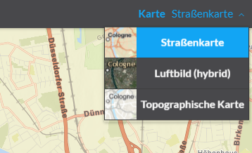
In addition the Basemaptoggler was revised and made available in map.apps 4. In addition to the textual representation of the different map contents, it is now possible to simply store icons or example images of the maps in order to simplify the selection of the suitable map for the user.
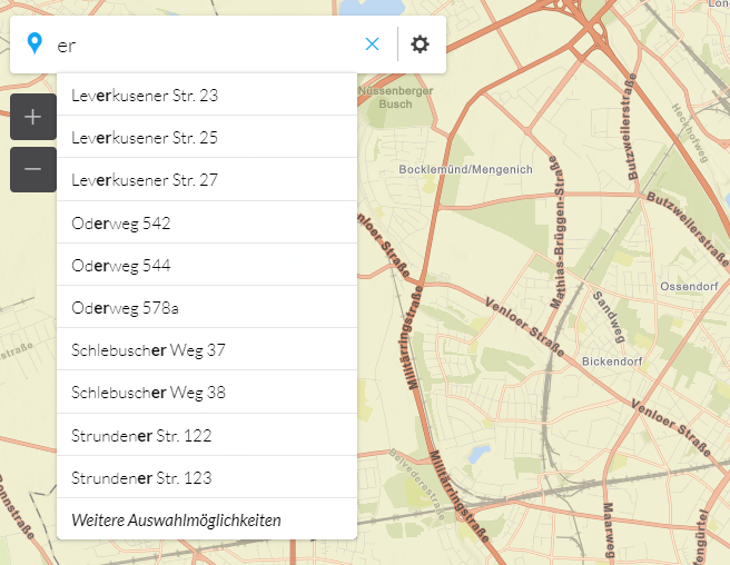
Search
map.apps 4 apps can now be flexibly and easily equipped with a search. The search on ArcGIS Server services can now be used in both 2D and 3D apps. A 3D icon can be used to display the search results.
Selection and Results Center
The rectangle selection of features and their representation in the Result Center is now also possible in apps based on bundle package 4.x. A CSV export allows you to work with the data selected in map.apps.
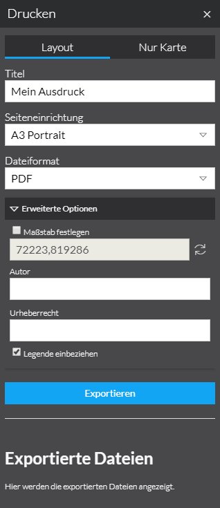
Printing
A print function is now available in map.apps 4 Apps, which allows the use of an ArcGIS Server Printing task to print 2D maps in various formats based on freely configurable templates.
Support for OGC WMS
Apps can now display map services that have been published according to the OGC Standard Wep Map Service (WMS).
Update of the Esri API for JavaScript
The version of Esri API for JavaScript used in map.apps has been updated to version 4.4. In addition to numerous other improvements, it is now possible to use pop-up arcade expressions in map.apps.
With Arcade Expressions, Values from other attributes can be calculated. The "proportion of total area" in the example below is e.g. not as an attribute in the data, but is calculated from the attribute "area" and the known total area on-the-fly.

A combination of free text, tables, diagrams or images can now be done in a popup. The various possibilities for the presentation of data will be presented in a separate blog post in the near future.
New Possibilities for Developer
map.apps 4.2.0 offers new ways of programming your own extensions: With Vue.js, developers have a powerful JavaScript framework in the area of widget programming. This allows data entry and output to be directly linked to data objects. This is complemented by Vuetify.js, an extensive component framework that makes widgets very easy to build.
Additional Improvements
The de-ch language code is now supported, whereby numbers, data etc. can be displayed in Swiss format (e.g., coordinates in the format 1'200'500.123). In addition, the update interval of the LocateMe function can be set.
For a complete list of changes, see the Release Notes.
Line 3
Bundle-Packet 3.9.0 (based on ArcGIS API for JavaScript 3)
Printing
When printing, it is now possible to display the print area in the map. In addition, the templates offered by the print service can be filtered by means of configuration in map.apps, so that only certain templates can be used in an app.
Additional Improvements
The version of Esri API for JavaScript used in map.apps has been updated to version 3.21. Also in bundle package 3.9.0 the language code de-ch is now supported, whereby numbers, data, etc. can be displayed in swiss format. The update interval of the LocateMe function can also be set.
For a complete list of changes, see the Release Notes.